20 Best Tips

A Geography Refresher

Our first week of school we started back with activities and books that were a refresher on geography terms for the girls and an intro to our geography studies for Zachary.

One of my favorite books that we have on hand is from Rand McNally ~ Geography & Map Activities: Beginner and we used this throughout the week along with the different books that we read.

Here’s the breakdown of our week to introduce and review:

Monday

  • What is a map? Why do we use maps? How do they help us?
  • How to identify features on a map {water, land, mountains, etc…}
  • Maps vs. Globes – looking at how the two are different from each other
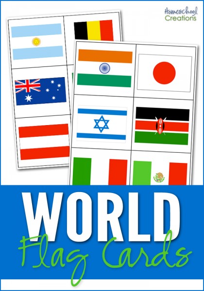
  • Continents and Oceans {use song to review}
  • How to use a map – reading the keys, knowing directions
  • North, South, East and West
  • Making a map – drew a map of our backyard ‘bird’s eye view’

Tuesday

  • Using a compass rose
  • Getting out of a maze following N/S/E/W directions
  • Making a treasure map – had kids hide a special treasure and then make a map to find it
  • Learned about the different hemispheres –
  • Talked about the Equator and Prime Meridian

Wednesday

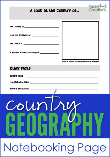
  • What are longitude and latitude?
  • Map legends and how to read them
  • How to read physical maps

Thursday

  • Time zones
  • Political maps
  • Put together continent puzzle
  • Label the continents and oceans on a blank map

Here are some of the fun books we read and used along with our studies this week:


And for those of you that are scratching your heads and thinking…”Ummm, didn’t she mention that they are in their fourth week of school already?” ~ the answer is yes, we are. I am giving myself a little bit of a buffer for posting our studies this year and wanted to get back into the swing of things before I started posting all that we are doing…it’s all still coming!!

Next week….we’re moving onto Spain!!

Photobucket

Country Flag Card Printables

world flag cards for matching

I’ve been working on this printable for far.too.long, and FINALLY sat down this weekend, got productive and have it ready to share with you all! :) I put these together to help our kids identify the flags of the various countries we’ve been studying during our Galloping the Globe studies {with a few extra countries thrown in for good measure}.

There are 35 countries represented on the cards with two cards for each flag so it can be played as a ‘memory’ game. The set also contains 6 cards that represent 6 of the 7 continents {Antarctica is excluded} so the cards can also be sorted by the continent the country flag belongs to. Country name cards are also included for your child to match the names of the countries with the appropriate flag.

Since I don’t know every flag and what country it belongs to *ahem*, I included a key at the end of the document to help you all double check your answers. :)


I hope that a few of these resources help you all out ~ let me know if you all have any questions or have problems with the download.

The Places We’ll Go…

I made a new form {surprise, surprise} to help me visualize our year in segments. I haven’t pinpointed exactly when we’re going to start…considering it would be most helpful to maybe get our schedule in place a little more before starting.

Truthfully, I’m stalling because I’m a little more nervous with figuring out a day with the three oldest. But shhhhh….

Click on the thumbnail to print off the form

I have figured out a rough plan of action and in case you were wondering what countries are in the works for this year and roughly when to expect them, here’s our outline:

Weeks 1-6: Intro/review, Spain, Italy and the solar system

Weeks 7-12: New Zealand, Australia, koalas, and South Africa

Weeks 13-18: South Africa, Kenya, and Morocco

Weeks 19-24: Nigeria, Egypt, {insert something related to Egypt here – specific, eh?}, and Brazil

Weeks 25-30: Brazil, Venezuela, Peru, and Argentina

Weeks 31-36: Argentina, Mexico, and Canada

Photobucket

Geography Notebooking Sheet / Travel Diary

Here are two geography notebooking pages to help you in your geography studies. 

country geography notebooking page

Country Geography Notebooking Page ~ Jot down some notes on the country you are studying: square miles, longitude/latitude, natural resources, religions, languages and more. It also has space to add a picture of the country you are learning more about.

country fact sheet notebooking page for geography studies

The Country Fact Sheet {or travel diary} can be used for any country {I left the country name area intentionally blank}. There are several boxes on the page to record information about the country being studied: Facts about the country, someone famous from the country, famous landmark(s), and other fun information about the country. There is room for children to draw their own pictures, add clip art and journal answers on the page. Click here to print/download the Country Fact Sheet.

So you can see how we used it, I scanned in a completed one for the country of France. Ok ~ not quite completed and sorry the picture is a little dark {grins}. The handwriting is a little funky because Laurianna is trying to be artistic and make fun letters…and then gets distracted halfway through…

Before we started the country fact sheet, I pulled out our atlas and jotted down a few things that I wanted to cover. For famous people I chose Claude Monet. Famous places ~ Notre Dame, Eiffel Tower and Arc de Triomphe. As we worked through our atlas we filled in some of the blanks and then the girls wrote a sentence or two about the other areas. I googled the places we were going to cover and created some ‘clip art’ for them to cut and paste onto the notebooking sheet.


When we are done, this page will go into our geography notebook for the girls to review later in the year. Here are a few more printables and resources to help you out as well.


Homeschool Geography Resources ~ My Top Picks

I’ve had several of you ask me recently what books I would recommend to use along with geography studies. What I started out using at the beginning of this year and what we are wrapping up our year using most are very different. Some of the changes have been because of the ages of our kids and others are just because we found some great books that we love!

These were some of our favorite resources that we referred to over and over during our ‘world travels’:

I’ve put in an Amazon carousel below so if you click on one of the picks it will take you to Amazon. I usually buy most of my books through them since they offer free shipping on orders over $25 {which sadly is too easy to come up with…or you can always use Prime shipping}.

  • Ten Boys & Girls Books ~ all four of the books have short stories about girls and boys who later grew up to be missionaries or help others in some way. These books are usually $6.99 at Amazon and are included right now in the 4 for 3 promotion {buy 4 eligible items and get the lowest priced one free}. We used the ‘changed the world’ and ‘made history’ books {4 total}
  • Around the World in 80 Tales ~ I wrote a review of this book earlier. Our kids literally beg for us to read a story from it each time we start a new country.
  • Rand McNally Schoolhouse Beginner Geography & Map Activities ~ we bought these to go along with the Beginner Atlas. It starts out with basic map/geography activities and then breaks it up by continent.
  • Pocket Factfiles: Mammals ~ small little book, but ever-so-handy for quick reference and look up
  • Children’s World Atlas – this one has links to the internet. Very handy!
  • GeoPuzzles ~ these are some of the best puzzles we’ve found and they have helped the kids learn and place countries too. There are puzzles for almost all of the continents. Ages 4 and up
  • Draw Write Now ~ we’ve used these to help us draw different animals from the countries that we are studying. I’m working on a list to post of the books/animals from different continents. We bought the whole set because the kids really enjoy them and they also provide journaling information
  • Draw Write Now ~ we picked this up from Rainbow Resource at a convention and the kids and I have learned the countries on the continents by singing our way through them. LOVE it!


Traveling France: Week 2

Testing is done and it was back to school as we know it. Groans and complaints aside, the week was very fun and even I learned a lot in the process {who says homeschooling is all about the kids, eh?}

The main focus this week was the Eiffel Tower because it was just too fun. :) The girls especially enjoyed picking one of Monet’s paintings to imitate {I picked 4 different paintings and let them choose one}.

When I tried to sit the girls down at the end of the week to put their notebooking pages into their binders and stamp their passports, Laurianna asked if we could study for another week and do a lapbook. So I’m going to be spending the next few days pulling together something for next week.

Monday

  • Geography song (kids are singing it to me while pointing to the countries on the map)
  • History of France {via Time for Kids} ~ I printed off what they provide for us to use in our notebooks
  • Read a few chapters of The Little Prince

Tuesday

  • Geography song
  • Visited the official website of the Eiffel Tower and took a 360 panoramic tour
  • Put together some paper crafts of the Eiffel Tower
  • Played a few games for fun (Hector at the Eiffel Tower)
  • Read The Cat Who Walked Across France by Kate Banks

Wednesday

  • Geography song
  • Practiced counting to 10 in French {see YouTube video clip below}
  • Read a few chapters in The Little Prince
  • The Travel Linguist ~ French 101 teaching some basic French phrases


Thursday

  • Geography song
  • Talked about Claude Monet & watched short documentary about him
  • Picked our own Monet painting to imitate
  • Read more in The Little Prince


Resources and Websites

Books We’re Using

Photobucket