- Like
- Digg
- Tumblr
- VKontakte
- Buffer
- Love This
- Odnoklassniki
- Meneame
- Blogger
- Amazon
- Yahoo Mail
- Gmail
- AOL
- Newsvine
- HackerNews
- Evernote
- MySpace
- Mail.ru
- Viadeo
- Line
- Comments
- SMS
- Viber
- Telegram
- Subscribe
- Skype
- Facebook Messenger
- Kakao
- LiveJournal
- Yammer
- Edgar
- Fintel
- Mix
- Instapaper
- Copy Link
When I first started doing our geography studies, I didn’t know how many people I would eventually be sharing my files with. For the first few countries we studied in Asia, there were no mapping projects created to go along with them.
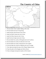
Several of you have emailed me asking if I either had them available or could pull them together. I’m slowly working through them {and will be posting Israel, Russia, and Korea soon!}, but posted a map notebooking page for China in case you all are interested! Just click on the thumbnail image below to download a copy.
The rest of my printables for the continent of Asia, including the country of China, can be found on my Asia Notebooking Printables page.
Here’s a quick peek at some of the other FREE geography lesson plans and geography printables that I have created:
- Geography Website
- Travel Log and Passports
- Geography Resources ~ Top Picks
- Africa Notebooking Printables
- Asia NotebookingPrintables
- Australia & New Zealand Notebooking Printables
- Europe Notebooking Printables
- North America Notebooking Printables
- South America Notebooking Printables
- Country Flag Cards
- Children Just Like Me Notebooking Page
- Geography Notebooking Sheet & Travel Diary


 The printables shared on this site are FREE of charge unless otherwise noted, and you are welcome to download them for your personal and/or classroom use only. However, free or purchased printables are NOT to be reproduced, hosted, sold, shared, or stored on any other website or electronic retrieval system (such as Scribd or Google docs). My printables are copyright protected and I appreciate your help in keeping them that way.
If you download and use some of my printables and then blog about them, please provide a link back to my blog and let me know - I'd love to see how you are using them! Please be sure to link to the blog post or web page and not directly to the file itself. Thank you!
I’ve been looking through your geography studies and I am just wondering what grade levels you think it is appropriate for. I love all of the fabulous work you share with us!
we primarily used it during our 1-3rd/4th grade years, but or
kindergarten participated in moderation with us too. :)